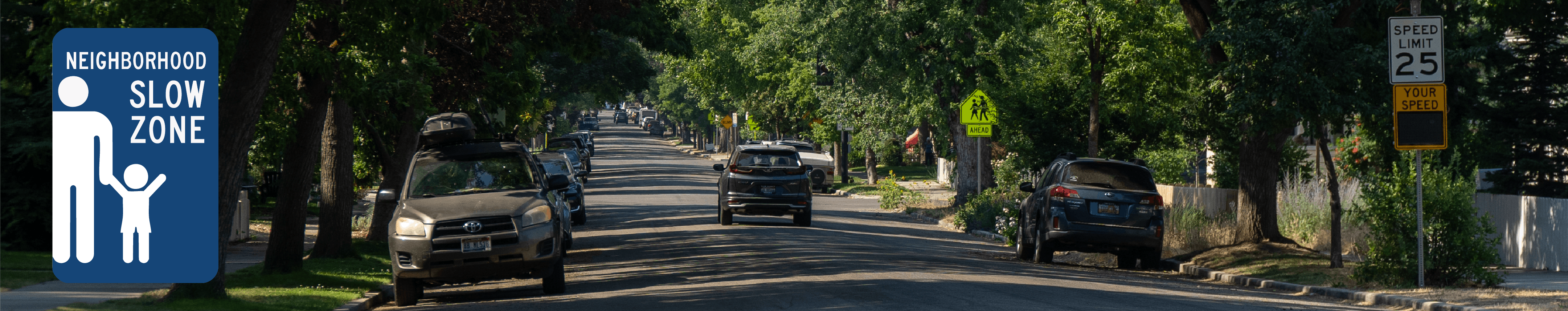
North End Neighborhood Slow Zone Pilot
The Ada County Highway District (ACHD), in partnership with the City of Boise, has launched a North End Neighborhood Slow Zone Pilot to improve safety for people walking, biking, rolling, and driving.
Lower Speed Limits
Beginning in January, ACHD reduced posted speed limits to 20 mph on select North End streets, including 8th Street, 9th Street, 13th Street, 15th Street, 16th Street, Fort Street, Hays Street, and Harrison Boulevard.
Crossing Flags
To support safer pedestrian crossings, ACHD installed pedestrian crossing flags at all marked crosswalks along Harrison Boulevard, not including the Hill Road intersection.
Speed and Parking Enforcement
The slow zone is supported by Boise Police enforcement. Enhanced parking enforcement is also underway to address illegal parking near intersections, stop signs, and crosswalks, helping improve visibility and reduce conflicts for all road users.
Education
The pilot is accompanied by outreach efforts by the City, Police and ACHD to encourage safer driving behaviors.
Monitoring and Evaluation
ACHD and the City of Boise will continue to monitor the pilot to evaluate whether the changes reduce vehicle speeds on corridors that typically operate between 25 and 30 mph.
Please note that this webpage will be updated as more information becomes available.
Speed Limit Changes Map

Videos


April 2026 Update

Pre-Pilot Traffic Speed Data
-
 Pre-Pilot Traffic Speed Data Summary Table (76.9 KB) (pdf)
-
 8th Street
-
9th Street
-
13th Street
-
13th St N-O Fort St - Spd 2022.pdf (338 KB) (pdf)
-
13th St S-O Bella St - Spd 2022.pdf (337 KB) (pdf)
-
2022 13th St - Ada St to Sherman St.pdf (324 KB) (pdf)
-
2025 13th St - Fort St to Resseguie St.pdf (176 KB) (pdf)
-
2025 13th St - Franklin St to Hays St.pdf (176 KB) (pdf)
-
2025 13th St - Irene St to Bella S (176 KB) (pdf)
-
-
15th Street
-
15th St N-O Sherman St - Spd 2020.pdf (517 KB) (pdf)
-
2020 15th St - Alturas St to Sherman St (2).pdf (230 KB) (pdf)
-
2020 15th St - Alturas St to Sherman St.pdf (227 KB) (pdf)
-
2021 15th St- Alturas St to Sherman St.pdf (261 KB) (pdf)
-
2022 15th St- Bella St to Hazel St.pdf (1.04 MB) (pdf)
-
2023 15th St - Ridenbaugh St to Lemp St (2).pdf (254 KB) (pdf)
-
2023 15th St - Ridenbaugh St to Lemp St.pdf (251 KB) (pdf)
-
2024 15th St - Front St to River St (2).pdf (253 KB) (pdf)
-
2024 15th St - Front St to River St.pdf (252 KB) (pdf)
-
2024 15th St- Bella St to Hazel St.pdf (253 KB) (pdf)
-
2025 15th St - Alturas St to Eastman St.pdf (174 KB) (pdf)
-
2025 15th St - Dewey St to Irene St.pdf (174 KB) (pdf)
-
2025 15th St - Hazel St to Heron St.pdf (174 KB) (pdf)
-
2025 15th St - State St to Fort St.pdf (177 KB) (pdf)
-
-
16th Street
-
Fort Street
-
2020 Fort St - 8th St to 16th St.pdf (160 KB) (pdf)
-
2020 Fort St - Ave B to 8th St.pdf (160 KB) (pdf)
-
2023 Fort St - 3rd St to 4th St (2).pdf (252 KB) (pdf)
-
2023 Fort St - 3rd St to 4th St.pdf (322 KB) (pdf)
-
2023 Fort St - 6th St to 7th St.pdf (318 KB) (pdf)
-
2023 Fort St - 7th St to 8th St.pdf (503 KB) (pdf)
-
2023 Fort St - 11th St to 12th St (2).pdf (378 KB) (pdf)
-
2023 Fort St - 11th St to 12th St (3).pdf (253 KB) (pdf)
-
2023 Fort St - 11th St to 12th St.pdf (506 KB) (pdf)
-
2023 Fort St - 13th St to 15th St.pdf (248 KB) (pdf)
-
Fort St E-O 12th St - Spd 2023.pdf (891 KB) (pdf)
-
-
Harrison Boulevard
-
2020 Harrison Blvd - Lemp St to Heron St (2).pdf (231 KB) (pdf)
-
2020 Harrison Blvd - Lemp St to Heron St.pdf (229 KB) (pdf)
-
2021 Harrison Blvd- Lemp St to Heron St.pdf (260 KB) (pdf)
-
2025 - Harrison Blvd - Dewey St to Irene St.pdf (177 KB) (pdf)
-
2025 Harrison Blvd - Alturas St to Eastman St.pdf (145 KB) (pdf)
-
2025 Harrison Blvd - Dora St to Dewey St (2).pdf (145 KB) (pdf)
-
2025 Harrison Blvd - Dora St to Dewey St.pdf (177 KB) (pdf)
-
2025 Harrison Blvd - Hazel St to Heron St.pdf (176 KB) (pdf)
-
Harrison Blvd N-O Dewey St - Spd 2022.pdf (895 KB) (pdf)
-
Harrison Blvd N-O Hazel St - Spd 2022.pdf (895 KB) (pdf)
-
Harrison Blvd N-O Lemp St - Spd 2020.pdf (528 KB) (pdf)
-
Harrison Blvd S-O Dewey St - Spd 2023.pdf (896 KB) (pdf)
-
-
Hays Street

Who's Listening
-
Accessibility and Mobility Supervisor

Phone 208-387-6100 Email connect@achdidaho.org